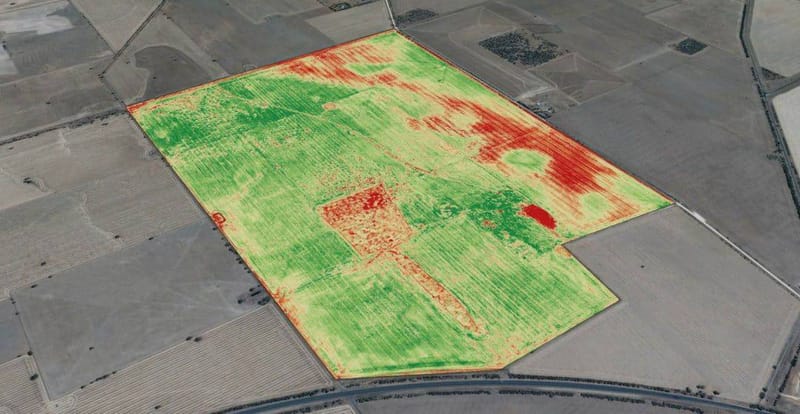
AGRICULTURAL HEALTH DRONE SURVEY

Video: Maryland Farm & Harvest
Gass Geoservices LLC is an innovative aerial surveying service that specializes in utilizing advanced drone technology equipped with thermal imaging cameras to conduct comprehensive and efficient health assessments of agricultural crops. Our business aims to address the increasing demand for accurate and timely information on crop health and yield potential by leveraging the power of thermal imaging and unmanned aerial vehicles.
At Gass Geoservices LLC, we understand the critical role that crop health plays in maximizing agricultural productivity and optimizing resource management. However, detecting early signs of stress, disease, or irrigation issues across vast agricultural fields can be a challenging and time-consuming task. Traditional surveying methods often require extensive manual labor and may lack the ability to provide a holistic view of crop health.
Our solution leverages state-of-the-art drones equipped with high-resolution thermal cameras capable of capturing detailed thermal images of crops from an aerial perspective. This cutting-edge technology allows us to identify and analyze temperature variations across agricultural fields quickly. By analyzing the thermal data, our experienced agronomists can detect and assess potential crop stress, water stress, nutrient deficiencies, or disease outbreaks, providing crucial insights for optimized crop management.
Gass Geoservices LLC offers a non-intrusive and efficient surveying service that minimizes the need for physical inspections and reduces costs associated with labor and resources. Our skilled drone pilots operate with precision, capturing detailed thermal images from multiple angles and elevations. The acquired data is then processed and analyzed using advanced algorithms and software, generating comprehensive reports that highlight areas of concern, recommend appropriate interventions, and help optimize crop management practices.
Our services cater to a wide range of clients, including farmers, agricultural cooperatives, precision agriculture companies, and crop consultants. By utilizing thermal drone surveys, our clients gain valuable insights into the health and performance of their crops, enabling them to make data-driven decisions to improve yields, minimize losses, and optimize resource allocation.
Gass Geoservices LLC is committed to delivering exceptional service quality, utilizing cutting-edge technology, and employing knowledgeable professionals. We adhere to strict safety standards and regulatory compliance to ensure the utmost safety and reliability of our operations. Our mission is to be the trusted partner for agricultural health surveys, providing accurate and actionable thermal imaging data that helps farmers optimize crop productivity, conserve resources, and promote sustainable agriculture practices.


